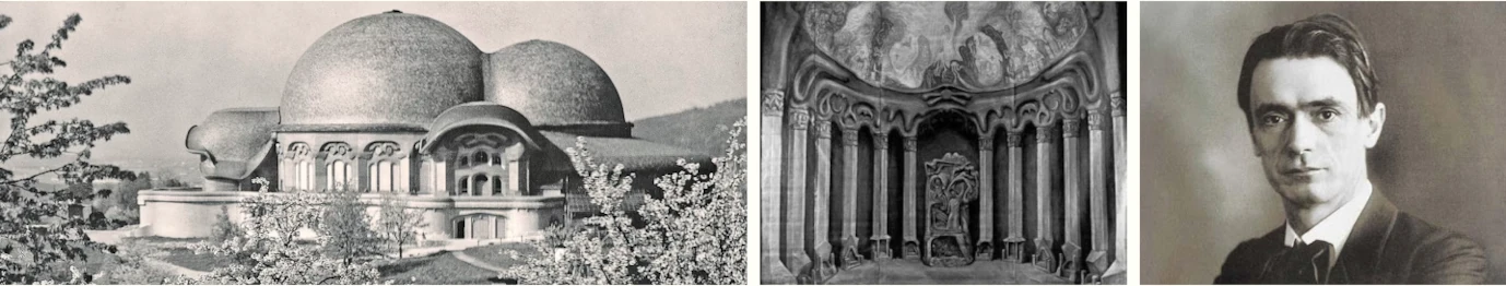
Practical Course for Teachers
GA 294
2 September 1919, Stuttgart
XI. On the Teaching of Geography
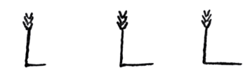
I have told you that the teaching of geography can first be begun at the second stage of the elementary school course. We can very well begin it after the age of nine. It remains to arrange it suitably. Wherever the elementary-school teaching of the future is in question—and this even holds good of teaching in senior schools (age 12-18)—we must see that geography embraces far more than it does at present. Geography at the moment retires only too much into the background; in fact, a step-motherly treatment is meted out to it. The achievements of the other subjects ought really in many ways to culminate in geography. And even if I said that the teaching of mineralogy should only begin at the third stage, round about twelve, mineralogy in the form of description and direct observation can be partly interwoven with geography as early as the previous stage. The child can absorb an extraordinary amount of geography between nine and twelve, if only we go about teaching it rightly. It is a question in geography above all of setting out from the child's own knowledge of the face of the earth and the processes which occur on its surface. We try first of all to convey to the child, again artistically, by a kind of picture, the relations of mountain and river and other aspects of his surroundings. In fact, we really work out with the child, in an elementary way, a map of the immediate surroundings in which he has grown up and with which he is familiar. We try to take the child through the difference between the view we have of a landscape if we ourselves stand on the land or look down to it from the air; that is, we show him the transformation into a map of the landscape immediately familiar to him. We try to show him how rivers flow through this stretch of land; that is, we actually draw the river and stream system of the surrounding country on the map into which we gradually transmute our view of the country. And we draw on it the physical features of the mountains and hills. It is a good thing to do this with colours, marking the rivers with blue and the mountains with brown chalk. But then we add to it the other features connected with human life. We mark the different configurations of the district, drawing the child's attention to them like this: “You see that part of the country is planted with orchards;” and we draw the fruit-trees.
We point out to him in addition the presence of needle-trees or pine woods and draw the stretches which are covered with conifers.
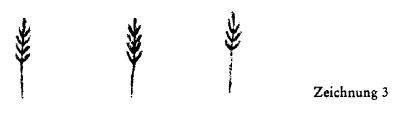
We direct his attention to the fact that part of the district is covered with corn and we draw these stretches too.
Then we direct his attention to the fact that there are meadows, which again we draw.
This drawing represents meadows which can be mown. We say so to the child. We also draw in the meadows which cannot be mown but which can be used for pasturing the cattle, which eat the grass and thus it remains short.
And we tell the child that this is pasture land. In this way we make the regional map live for him. It gives him some sort of survey over the economic foundations of the district. Then, too, we point out to him that mountains contain all kinds of things: coal, ore, etc. And we further point out that the rivers are used for shipping the produce or manufactures of one place to another. We thus lead him to deduce therefrom a good deal about the economic implications of the structure of the country. When we have made clear the economic foundations in the form of rivers and mountains, meadows and forest, etc., as far as the child is able to understand our knowledge of these, we draw in, at the corresponding spots, the villages or towns included in the district which we are studying first. And then we begin to point out the connection between the growth and development of villages at definite spots and the wealth of the mountains or the courses of streams and rivers. In short, we try by means of the map to give the child some simple idea of the economic connections between the natural formation of the land and the conditions of human life, and of the difference between the conditions of life in the country and in the towns. As far as the child can understand this aspect we must not fail to pursue it. And last of all we go as far as to show how man, by his labour, overcomes natural conditions. That is: we begin to open the child's eyes to the fact that man lays out artificial rivers in canals, that he builds railways for himself. Then we show how these railways determine the part played by provisions, and so on, and even people, in life. When we have tried for some time to give the child an idea of the economic connection between natural relations and the conditions of human life, we can put the idea thus introduced into the vaster terms of the earth. Here, if we have only taken the first stage correctly, we shall not need to display much pedantry. The pedant will say at this point: “It is natural first to study the geography of the immediate neighbourhood and then, concentric with this, to extend the study on every side.” That, of course, is pedantry. There is no need to enlarge in this way. But when a foundation has been laid for an understanding of the connection between nature and human beings, another aspect can perfectly well be studied. Accordingly, you now pass on to some aspect from which you can develop as well and intensively as possible the economic relations between men and natural conditions. For instance, in the case of our Swabian district, after developing the necessary ideas from familiar stretches of land and indicating to the child, as you go on, the direction you are taking—widening, as it were, his horizon—tell him about the Alps, study the geography of the Alps. You have taught him how to draw maps. You can now extend his drawing of maps by marking for him the line where the Southern Alps touch the Mediterranean Sea. In drawing for him the Northern part of Italy, the Adriatic Sea, etc., you indicate the great rivers and draw their course on the surrounding country. You can go on from this to draw for him the Rhone, the Rhine, the Inn, the Danube, with their tributaries. Then you can draw in the separate arms of the Alpine range. And the child will be extraordinarily fascinated by the sight of the different arms, for instance, of the Alpine range, parted from each other by the course of the rivers. Do not hesitate to mark, all along the blue lines of the rivers, red lines, which are now imaginary lines, up the Rhone from Lake Geneva to its source, and along the Rhine. Then continue the line over the Arlberg Pass, etc., then draw another line along the Drau, etc., dividing the Alps by these red lines drawn from west to east, so that you can say to the child: “You see, along the course of the rivers, I have drawn red lines. The Alps lying between the two red lines are different from those lying above and below.” And now you show him—here the teaching of mineralogy springs from geography—a piece of Jura limestone, for instance, and say: “You see, the mountain masses above the top red line are made of limestone like this, and the mountains beneath the red line are made of different limestone.” And for the mountains lying between, show him a piece of granite, or gneiss, and say: “The mountain range between the two is made of rock like this, which is primary rock.” And he will be tremendously interested in this Alpine structure, which you perhaps explain to him from a regional map showing the lateral perspective as well as the aerial view, and if you make clear to him plastically that the river-courses divide the Alps into limestone and gneiss and slate, and that these stand side by side the whole length of the mountain range from south to north, bending towards the north: limestone mountains—granite mountains—limestone mountains, parted from each other by the river courses. Without any pedantic object lessons the child's range of ideas can be enlarged by many illuminating features relating to this study.
Then you go on—you have already created the necessary elements for this in your nature-teaching—to describe to the child what grows down in the valley, what grows further up, and what grows at the very top. You approach vegetation vertically.
And now you begin to show the child how people establish themselves in the kind of country which is chiefly dominated by the mountain structure. You begin to describe quite vividly a little mountain village situated really high up, you draw this, and tell of the people living there. And you describe a village lying down below in the valley, with roads. Then the towns lying at the confluence of a tributary with its river. Then you describe again, in these wider terms, the relation of human economics to natural formations. You build up, as it were, human economic life out of nature, by pointing out to the child where there is ore, and coal, and how these determine human settlements, etc.
Then you draw for him a district poor in mountains, a flat district, and treat this in the same way. First describe the natural aspects, the constitution of the soil, and show at this early point that different things flourish in a poor soil from a rich soil. You show the internal composition of the soil—this can be done quite simply—in which potatoes grow; the composition of the soil in which wheat grows, in which rye grows, etc. You have already taught the child, of course, the difference between wheat, rye, and oats. Do not hesitate at this early stage to teach him many facts which he will only understand for the time being in a general way, and will only understand more clearly when they are referred to in a later lesson from another point of view. But up to twelve years of age familiarize the child chiefly with economic relations. Make these clear to him. Prefer to show him many points of view in geography rather than a complete picture of the earth at this time. It is, however, important to show that the sea is very vast. You have already begun to draw it with the Southern Alps, where you drew the outline of the Mediterranean Sea. You show the sea by a blue surface. Then draw for the child the outlines of Spain, of France, and then show in your drawing how, towards the west, there lies a great ocean, and gradually open his eyes to the fact that there is America besides. He should get this idea before he is twelve.
You see, if you begin like this with a good foundation, when the child is about twelve, you can expect him to respond easily to a more systematic survey with the five continents, the seas, and with a description—rather briefer, indeed, than the earlier one—of the economic life of these different parts of the earth. You ought to be able to develop all this from the foundations already laid. When—as I said—you have summarized for the whole earth the knowledge of economic life which you have implanted in the child, go on—when you have been teaching history for six months on the lines we have discovered—to talk to the children of the spiritual condition of the people who inhabit the different parts of the earth. But be careful only to introduce this lesson when you have attuned the child's soul to it in some degree by the first history lessons. Then speak, too, about the spatial distribution of the characteristics of the different peoples. But do not speak of the different characters of the individual peoples earlier than this, for, on the basis which I have described, it is at this point that the child brings the greatest understanding to bear on such teaching. You can now describe to him the differences between the Asiatic, the European, the American peoples, and the differences between the Mediterranean races and the Nordic races of Europe. You can then go on to combine geography gradually with history. You will find it a beautiful and enjoyable task when you do what I have recommended chiefly between the age of twelve and the end of the elementary school course; that is, in the end of the fifteenth year. You see that a tremendous amount should be put into the teaching of geography, so that, in fact, the geography lesson is like a resume of much that is learnt. What cannot flow together and merge in geography! Finally, you will even come to a wonderful interplay of geography and history. Here, if you have contributed generously in this way to the geography teaching, you will be able to extract as many things out of it. This, of course, involves a demand on your imaginative powers, on your gift for invention. When you tell the child that here or there a certain thing is done, for instance: “The Japanese make their pictures like this,” try to encourage the child to make something of the same kind in his simple primitive way. Do not omit, even at the beginning, when showing the child the connection between agriculture and human life, to give him a clear idea of the plough, of the harrow, etc., in connection with his geographical ideas. And try especially to make the child imitate the shapes of some of these implements, even if only in the form of a little plaything or piece of handiwork. It will give him skill and will fit him for taking his place properly in life later on. And if you could even make little ploughs and let the children cultivate the school garden, if they could be allowed to cut with little sickles, or mow with little scythes, this would establish a good contact with life. Far more important than skill is the psychic intimacy of the child's life with the life of the world. For the actual fact is: a child who has cut grass with a sickle, mown grass with a scythe, drawn a furrow with a little plough, will be a different person from a child who has not done these things. The soul undergoes a change in doing these things. Abstract teaching of manual skill is really no substitute. And the laying of little sticks and plaiting paper should be avoided as much as is reasonably possible, because these tend to unfit man for life rather than fit him for it. It is far better to encourage the child to do things which are really done in life, than to invent things foreign to it. In arranging the child's geography lessons in the way I have described we make him familiar in the most natural possible way with the fact that human life is made up in different ways from different sides. And at the same time we are dealing with what he can understand perfectly. We describe to him first, from nine to twelve years of age, economic and external aspects in the geography lessons. We then lead him on to understand the cultural conditions, the spiritual conditions of the different peoples. And at this point, saving up everything else for a later time, we gently indicate the relations of right (Rechtsverhältnisse: legal conditions) which prevail among these peoples. But we only let the first and most primitive ideas of this kind glimmer through the picture of economic and spiritual life. For the child cannot yet fully understand conditions of right. If he is acquainted too early with these ideas of conditions of right, the forces of his soul for the whole of life will be impoverished, because conditions of right are a very abstract matter.
It is, in fact, a good thing to employ the geography lesson to bring unity into the rest of teaching. It is, perhaps, precisely for geography the very worst thing that could happen that it has been assigned a place in the severely demarcated time-table, which we do not want in any case.
Our whole attitude from first to last will be one of dealing with the same subject of study for some length of time. We receive the child into school and devote our attention first of all to teaching him to write. That is: we occupy the hours which we claim from his morning in teaching him to paint, draw, write. We do not draw up a time-table according to which we write in the first lesson, read in the second, etc., but we deal for longer periods at a time with things of the same nature. We only go on later to reading, when the child can already write a little. He learns to read a little, of course, while writing. But an even better combination can be effected. For the later subjects, too, we set definite time-limits within which they are to be studied, but not so that we always have a lesson in one subject following on a lesson in another, but so that we keep the children busy for some time at one subject, and then, only when they have been engaged on it for weeks, turn to something else. This concentrates the teaching and enables us to teach much more economically than if we were to allow the appalling waste of time and energy involved in taking one subject first and extinguishing it in the next lesson. But particularly with geography, you can see how it is possible to pass from every imaginable subject to geography. You will not have it laid down beforehand: geography must be taught from nine to ten years of age; but it will be left to you to choose the time suitable for going on, from what you have already taught, to geographical explanations.
This, of course, imposes upon you a great responsibility, but without this responsibility teaching is impossible. A system of teaching which lays down beforehand the teacher's time-table and every imaginable limitation, actually, and, moreover, completely, excludes the teacher's art. And this must not be. The teacher must be the driving and stimulating element in the whole being of the school. Particularly from the way in which I have shown you how to teach geography you should get a correct idea of the right procedure in teaching from first to last. Geography can really be a vast channel into which everything flows, from which in return much can be drawn. For instance, you have shown the child in geography the difference between limestone mountains and primary mountains. You show him the constituents of the primary mountain-rock, granite or gneiss. You show him how they contain different minerals, how one of these is a sparkling substance whose presence is shown by a glitter—the mica. And then you show him all the others that are contained in granite or gneiss. Then you show him quartz and try to evolve the mineral element from rock-substance. Particularly here you can do a great deal towards developing a sense for the association of facts and a united whole. It is much more helpful to show the child granite and gneiss first, and then the minerals of which they consist, than to teach him first of all: granite consists of quartz, mica, feldspar, etc., and only afterwards show him that these are combined in granite or gneiss. Particularly in mineralogy you can go from the whole to the part, from the structure of mountains to mineralogy. And it helps the child.
With the animal kingdom you will proceed in the opposite way, by building it up from the separate animals. We must treat the plant kingdom, as you saw in our discussion in the seminary class,1See R. Steiner, “The Training of Teachers” (“Pädogogisches Seminar”), published in the periodical, The Art of Education (“Erziehungskunst”), Nos. 6 and 7. as a whole, and then enter into the details. In the mineral kingdom nature itself often gives us the whole and we can go from this to the part.
But here you must not omit—again connecting mineralogy with geography—to speak about the uses to which the economic resources of nature are put. We shall link up our discussion of the rock-formation of mountain ranges with all the uses of such things as coal for industry. At first we shall only describe it simply, but we shall connect it descriptively with the talk about the mountains.
Nor should we neglect, in describing the forest, for instance, to describe the saw-mill. First we lead over from the forest to the wood, and from the wood to the saw-mill.
We can do a tremendous amount in this direction if we do not begin with a time-table marked out like Regimental Orders, but follow the suggestions of past lessons. We must simply have a good idea of the demands of the child's nature at the age when he begins school up to nine years of age, from nine to twelve, and from twelve to fifteen.
Elfter Vortrag
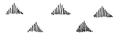
Ich habe Ihnen gesagt, daß der Geographieunterricht zuerst auf der zweiten Stufe des Volksschulalters auftreten kann. Wir können gut mit dem Geographieunterricht beginnen, wenn das 9. Lebensjahr überschritten ist. Wir müssen ihn nur in der richtigen Weise einrichten. Wir müssen überhaupt beim Volksschulunterricht der Zukunft — das gilt sogar auch für den Mittelschulunterricht — darauf sehen, daß dieser Geographieunterricht viel mehr umfaßt, als er gegenwärtig umfaßt. Das Geographische tritt in der Gegenwart allzusehr zurück, es wird wirklich recht stiefmütterlich behandelt. Mit dem Geographischen sollten eigentlich die Errungenschaften des übrigen Unterrichts in vielfacher Beziehung wie in eins zusammenfließen. Und wenn ich Ihnen auch gesagt habe, daß der Mineralogieunterricht erst auf der dritten Stufe, so um das 12. Jahr herum auftritt, so kann doch beschreibend, anschauend auch das Mineral schon auf der früheren Unterstufe etwas in dasGeographische verflochten werden. Das Kind kann außerordentlich viel zwischen dem 9. und 12. Jahr aus der Geographie aufnehmen, wenn wir nur richtig mit dieser Geographie verfahren. Da handelt es sich darum, daß wir gerade in der Geographie von dem ausgehen, was das Kind in irgendeiner Weise von der Oberfläche der Erde und dem, was auf der Oberfläche der Erde geschieht, schon kennt. Wir versuchen, dem Kinde zunächst kunstgemäß wiederum eine Art Bild beizubringen von den Gebirgs- und Flußverhältnissen, aber auch den sonstigen Verhältnissen der Umgebung. Wir machen es so, daß wir wirklich mit dem Kinde elementarisch eine Karte ausarbeiten für die nächste Umgebung, in der das Kind aufwächst, die es kennt. Wir versuchen, dem Kinde dasjenige beizubringen, was die Übersetzung bietet von dem Drinnensein in einer Gegend zum Anschauen aus der Luftperspektive oder durch die Luftperspektive, also richtig die Verwandlung der zunächst bekannten Gegend in die Karte. Wir versuchen dem Kinde beizubringen, wie die Flüsse diese Gegend durchfließen, das heißt, wir zeichnen das Fluß- und Bachsystem der Umgebung in die Karte, in die wir allmählich die Anschauung der Umgebung verwandeln, wirklich ein. Und wir zeichnen auch in diese Karte die Gebirgsverhältnisse ein, Es ist gut, wenn wir da mit Farben arbeiten, wenn wir die Flüsse blau einzeichnen, wenn wir die Gebirge mit brauner Kreide einzeichnen. Dann aber zeichnen wir auch in diese Karte die übrigen, mit den menschlichen Lebensverhältnissen zusammenhängenden Dinge ein. Wir zeichnen in diese Karte die verschiedenen Konfigurationen der Gegend ein, indem wir das Kind darauf aufmerksam machen: Sieh einmal, ein gewisser Teil der Gegend ist mit Obstbäumen bepflanzt und wir zeichnen die Obstbäume ein (siehe Zeichnung 1). Wir machen das Kind aufmerksam, daß auch Nadelwald da ist und zeichnen auch die Gebiete ein, die mit Nadelwald bedeckt sind (siehe Zeichnung 2). Wir machen das Kind aufmerksam, daß ein Teil der Gegend bedeckt ist mit Getreide und zeichnen diese Gegenden auch ein (siehe Zeichnung 3).
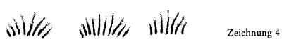
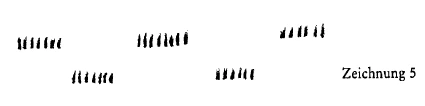
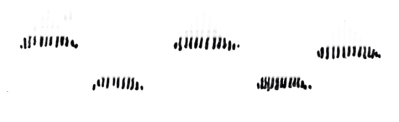
Dann machen wir es aufmerksam, daß Wiesen da sind und zeichnen sie ein (siehe Zeichnung 4). Diese Zeichnung stellt die Wiesen dar, die wir abmähen können. Das sagen wir dem Kinde. Die Wiesen, die wir nicht abmähen können, die wir aber doch dazu benutzen können, daß das Vieh darauf getrieben wird und das Gras frißt, das dort niedrig, spärlich bleibt, die zeichnen wir auch ein (siehe Zeichnung 5), und sagen dem Kinde, daß das Hutweiden sind. So machen wir die Landkarte für das Kind lebendig. Das Kind bekommt durch diese Landkarte eine Art Überblick über die wirtschaftlichen Grundlagen der Gegend. Dann aber machen wir das Kind auch schon aufmerksam darauf, daß in den Bergen drinnen allerlei ist: Kohle, Erze und so weiter. Und wir machen das Kind weiter aufmerksam, daß die Flüsse benützt werden, um Dinge, die an einem Orte wachsen oder fabriziert werden, an den andern Ort zu verfrachten. Wir führen ihm vieles von dem aus, was zusammenhängt mit dieser wirtschaftlichen Gestaltung einer Gegend. Nachdem wir die wirtschaftlichen Grundlagen in Flüssen und Bergen, in Wiesen, Wald und so weiter klargemacht haben, soweit das möglich ist nach den Kenntnissen, die wir dem Kinde beibringen können, zeichnen wir ein an die gehörige Stelle die Dörfer oder Städte, die in dem Gebiet sind, das wir zuerst vornehmen wollen. Und dann beginnen wir, das Kind darauf hinzuweisen, womit es zusammenhängt, daß gerade an bestimmten Orten Dörfchen sich entwickeln, wie das zusammenhängt mit dem, was in den Bergen ist, was man da hervorbringen kann, wie es zusammenhängt mit den Bach- und Flußläufen. Kurz, wir versuchen an der Landkarte schon eine gewisse Vorstellung hervorzurufen im Kinde von den wirtschaftlichen Zusammenhängen zwischen der Naturgestaltung und den menschlichen Lebensverhältnissen, dann versuchen wir, in dem Kinde eine gewisse Vorstellung hervorzurufen von dem Unterschiede zwischen den ländlichen und den städtischen Lebensverhältnissen. Soweit das Kind diese Sache schon begreifen kann, betreiben wir das durchaus. Und zuletzt gehen wir auch schon zu dem über, was der Mensch durch seine Wirtschaft tut, um von sich aus den Naturverhältnissen entgegenzukommen. Das heißt, wir beginnen das Kind aufmerksam zu machen, daß der Mensch künstliche Flüsse anlegt in den Kanälen, daß er sich Eisenbahnen baut. Dann machen wir das Kind darauf aufmerksam, wie durch die Eisenbahnen die Lebensmittel und dergleichen und die Menschen selbst ins Leben hineingestellt werden. Haben wir eine Zeitlang dahin gearbeitet, daß das Kind den wirtschaftlichen Zusammenhang zwischen den Naturverhältnissen und den menschlichen Lebensverhältnissen begreift, dann können wir das, was wir so an Begriffen in dem Kinde hervorgerufen haben, benützen, um die Sache in die größeren Erdenverhältnisse hinauszutragen. Da wird es, wenn wir nur diese erste Stufe richtig gemacht haben, nicht notwendig sein, daß wir einen großen Pedantismus entfalten. Der Pedant wird jetzt sagen: Das Natürliche ist, daß wir zuerst die engste Heimatkunde geographisch betreiben und dann konzentrisch die Sache weiter ausdehnen. — Das ist schon Pedanterie. So braucht man den Aufstieg nicht zu machen. Sondern wenn man eine Grundlage geschaffen hat für das Begreifen des Zusammenhanges von Natur und Menschenwesen, dann kann man auch ruhig zu etwas anderem übergehen. Man geht dann so auf etwas anderes über, daß man auch noch möglichst gut und intensiv wirtschaftliche Zusammenhänge zwischen dem Menschen und den Naturverhältnissen entwickeln kann. Man gehe zum Beispiel für unsere Gegend hier, nachdem man die nötigen Begriffe an den bekannten Territorien entwickelt hat, indem man das Kind örtlich orientiert, indem man gewissermaßen seinen Horizont erweitert, dazu über, daß man dem Kind sagt: Es gibt die Alpen. -— Man gehe über zur Geographie der Alpen. Man hat das Kind gelehrt Landkarten zeichnen. Man kann jetzt das Landkartenzeichnen dadurch ausdehnen, daß man dem Kinde die Linie hinzeichnet, welche das Gebiet der Südalpen angrenzen läßt an das Mittelländische Meer. Indem man dem Kind aufzeichnet das nördliche Stück von Italien, das Adriameer und so weiter, sagt man ihm: Es gibt da große Flüsse - und zeichnet in dieses Gebiet auch die Flußläufe ein. Man kann dann dazu übergehen, ihm zu zeichnen: die Rhone, den Rhein, den Inn, die Donau mit ihren Nebenflüssen. Man kann dann da hineinzeichnen die einzelnen Glieder des Alpenbaues. Und es wird das Kind außerordentlich gefesselt werden, wenn man ihm klarmacht, wie die einzelnen Glieder zum Beispiel des Alpenbaues durch die Flußläufe vorleinander geschieden sind. Man zeichne ruhig längs der blauen Linien der Flüsse rote Linien, die jetzt ideelle Linien sind, zum Beispiel die Rhone entlang, vom Genfer See bis zum Ursprung und gehe dann über zum Rhein und so weiter, zeichne dann die Linie hinüber über den Arlberg und so weiter, dann die Linie Drau, Enns und so weiter, um auf diese Weise durch solche rote Linien in der Richtung von Westen nach Osten die Alpen zu gliedern, so daß man dem Kinde sagen kann: Sieh einmal, ich habe jetzt längs der Flußläufe unten eine rote Linie gezogen und oben eine rote Linie gezogen. Was zwischen diesen zwei roten Linien ist, das sind andere Alpen als was oben, oberhalb der roten Linie, und was unten, unterhalb der roten Linie ist. - Und jetzt zeige man dem Kinde — da geht dann der mineralogische Unterricht auf in dem geographischen, er quillt hervor zum Beispiel ein Stück Jurakalk und sage ihm: Sieh einmal, die Gebirgsmassen oberhalb der oberen roten Linie, die bestehen aus solchem Kalk und was wiederum unter der roten Linie ist, besteht auch aus solchem Kalk. — Und was da zwischen drinnen ist, dafür zeige man ihm ein Stück Granit, Gneis und sage ihm: Das Gebirge mitten drinnen besteht aus solchem Gestein, das Urgestein ist. - Und das Kind wird sich schon ungeheuer für dieses Alpenmassiv interessieren, das Sie ihm vielleicht noch an einer Territorienkarte zeigen, wo auch die Seitenperspektive da ist und nicht nur die Luftperspektive, wenn Sie ihm plastisch klarmachen, daß durch die Flußläufe geschieden werden in den Alpen: Kalkalpen. Gebirgsläufe mit Gneis, Glimmerschiefer, Tonschiefer und so weiter und daß sich das Gebirgsmassiv, die ganze Gebirgskette von Süden nach Norden, indem sie nur gebogen ist, so nebeneinanderstellt: Kalkgebirge — Urgebirge - Kalkgebirge, geschieden durch die Flußläufe. Vieles, was nicht pedantischer Anschauungsunterricht ist, was die Begriffswelt des Kindes sehr erweitert, können Sie drangliedern.
Dann aber gehen Sie dazu über — Sie haben dazu schon die Elemente im Naturunterricht geschaffen -, dem Kinde zu schildern, was unten im Tal wächst, was weiter oben wächst und was ganz oben wächst und auch, was ganz, ganz oben wieder nicht wächst. Sie gehen über zur Vegetation in vertikaler Richtung.
Und jetzt beginnen Sie, das Kind darauf aufmerksam zu machen, wie sich der Mensch in eine solche Gegend hineinstellt, die vorzugsweise durch das Gebirgsmassiv bestimmt ist. Sie beginnen ihm zu schildern, ganz anschaulich, ein recht hochgelegenes Gebirgsdörfchen, das Sie ihm einzeichnen, und wie da die Menschen leben. Und ein unten im Tal gelegenes Dorf und Straßen schildern Sie ihm. Und dann die Städte, die dort sind, wo ein Fluß einen Nebenfluß aufnimmt. Dann schildern Sie wiederum in diesen größeren Zusammenhängen das Verhältnis der Naturgestaltung zum menschlichen Wirtschaftsleben. Sie bauen gewissermaßen aus der Natur heraus dieses menschliche Wirtschaftsleben auf, indem Sie das Kind auch aufmerksam machen, wo wiederum Erze und Kohlen sind, wie diese die Ansiedlungen bestimmen und so weiter.
Dann zeichnen Sie ihm eine gebirgsarme Gegend, eine ebene Gegend auf und behandeln diese ebenso. Zuerst schildern Sie das Naturmäßige, die Beschaffenheit des Bodens und machen jetzt schon darauf aufmerksam, daß auf einem mageren Boden etwas anderes gedeiht wie auf einem fetten Boden. Sie machen darauf aufmerksam, wie der Boden innerlich beschaffen ist — mit einfachen Mitteln kann man das -, auf dem Kartoffeln wachsen; wie der Boden beschaffen ist, auf dem Weizen wächst, auf dem Roggen wächst und so weiter. Sie haben ja dem Kinde schon vorher den Unterschied zwischen Weizen, Roggen, Hafer beigebracht. Da halten Sie nicht zurück, manches schon dem Kinde beizubringen, was es zunächst nur so im allgemeinen begreift, was es erst deutlicher begreift, wenn es wiederum von einem andern Gesichtspunkte aus im späteren Unterricht darauf zurückgewiesen wird. Führen Sie aber bis zum 12. Jahr hin das Kind vorzugsweise in die wirtschaftlichen Verhältnisse ein. Machen Sie ihm diese klar. Innere Geographie treiben Sie mehr, als daß Sie darauf sehen, schon in dieser Zeit ein vollständiges Bild der Erde zu geben. Aber wichtig ist es doch, schon darauf aufmerksam zu machen, daß das Meer sehr groß ist. Sie haben es schon begonnen zu zeichnen bei den Südalpen, wo Sie das Mittelländische Meer angrenzend gezeichnet haben. Das Meer zeichnen Sie dann als blaue Fläche auf. Dann zeichnen Sie dem Kinde auf die äußeren Umrisse von Spanien, von Frankreich, zeichnen ihm dann auf, wie nach dem Westen zu ein großes Meer liegt und führen es so langsam dazu über, daß es begreifen lernt, daß es auch Amerika gibt. Das sollte man schon vor dem 12. Jahr als Vorstellung hervorrufen.
Wenn Sie so mit einem guten Unterbau beginnen, dann können Sie um das 12. Jahr herum bei dem Kinde darauf rechnen, daß es Ihnen Verständnis entgegenbringt, wenn Sie nunmehr schon systematisch vorgehen, wenn Sie eine kürzere Zeit hindurch darauf sehen, daß das Kind wirklich ein Bild der Erde bekommt, indem Sie ihm die fünf Erdteile beibringen, die Meere - allerdings in einer kürzeren Weise als Sie es früher gemacht haben — und nun das wirtschaftliche Leben dieser verschiedenen Erdgebiete beschreiben. Aus dem, was Sie als Grundlage gelegt haben, müßten Sie da das andere alles hervorholen. Wenn Sie, wie gesagt, zusammengefaßt haben über die ganze Erde hin das, was Sie an Erkenntnis über das Wirtschaftsleben in das Kind gelegt haben, dann gehen Sie dazu über, gerade in den Momenten, wo Sie vielleicht schon ein halbes Jahr in der Weise Geschichte lehrten, wie wir es gelernt haben, nunmehr die geistigen Verhältnisse der Menschen, die die einzelnen Erdgebiete bewohnen, mit den Kindern zu besprechen. Versäumen Sie es aber nicht, diesen Unterschied dann erst eintreten zu lassen, wenn Sie die Seele dazu etwas gefügig gemacht haben durch den ersten geschichtlichen Unterricht. Dann reden Sie auch über die räumliche Verteilung der Charakterverhältnisse der einzelnen Völker. Aber reden Sie nicht früher über die Charakterunterschiede der einzelnen Völker als gerade um diese Zeit, denn da bringt das Kind auf jener Unterlage, die ich Ihnen geschildert habe, diesem Unterricht das meiste Verständnis entgegen. Da können Sie ihm davon sprechen, wie der Unterschied der asiatischen, der europäischen, der amerikanischen Völker ist, wie der Unterschied der mittelländischen Völker und der nordischen Völker Europas ist. Da können Sie übergehen dazu, Geographie mit Geschichte allmählich zu verbinden. Sie werden hier einer schönen und das Kind erfreuenden Aufgabe entsprechen, wenn Sie das, was ich jetzt geschildert habe, vorzugsweise zwischen dem 12. Jahr und dem Ende der Volksschulzeit treiben, so bis gegen das 15. Jahr hin. Sie sehen, daß man in den Geographieunterricht außerordentlich viel hineinlegen sollte, damit tatsächlich der Geographieunterricht eine Art Zusammenfassung desjenigen werde, was man sonst betreibt. Was kann alles in der Geographie zusammenfließen! Zum Schlusse wird sich sogar ein wunderbares Ineinandergestalten zwischen Geographie und Geschichte ermöglichen lassen. Dann werden Sie, wenn Sie so in den Geographieunterricht manches hineingetragen haben, auch wiederum manches aus ihm herausholen können. Da wird natürlich an Ihre Phantasie, an Ihre Erfindungsgabe einige Anforderung gestellt. Wenn Sie dem Kinde erzählen, da oder dort wird dieses oder jenes gemacht, zum Beispiel: die Japaner machen ihre Bilder so und so, dann versuchen Sie gerade das Kind anzuhalten, so etwas auch in seiner einfachen, primitiven Weise zu machen. Versäumen Sie es schon am Anfang nicht, indem Sie dem Kinde den Zusammenhang zwischen dem Ackerbau und dem menschlichen Leben beibringen, dem Kinde eine deutliche Vorstellung von dem Pflug, von der Egge und so weiter im Zusammenhang mit den geographischen Vorstellungen zu geben. Und einiges davon versuchen Sie namentlich von dem Kinde nachahmen zu lassen, wenn auch als kleines Spiel- oder Kunstwerk. Dadurch wird das Kind geschickt, und dadurch wird das Kind geeignet gemacht, sich später in richtiger Weise ins Leben hineinzustellen. Und wenn man gar könnte kleine Pflüge machen und die Kinder im Schulgarten ackern lassen, wenn man sie könnte mit kleinen Sicheln mähen lassen oder mit kleinen Sensen schneiden lassen, so würde man eine gute Verbindung zum Leben herstellen. Denn wichtiger als die Geschicklichkeit, ist die seelische Verbindung zwischen dem Leben des Kindes und dem Leben in der Welt. Denn es ist tatsächlich so: ein Kind, das mit der Sichel Gras abgeschnitten, mit der Sense Gras abgemäht hat, das mit einem kleinen Pflug Furchen gezogen hat, wird ein anderer Mensch als ein Kind, welches das nicht getan hat. Das Seelische wird dadurch einfach etwas anderes. Der abstrakte Handfertigkeitsunterricht kann das eigentlich nicht ersetzen. Und das Stäbchenlegen und Papierflechten, das sollte tunlichst vermieden werden, weil es eher abbringt davon, den Menschen ins Leben hineinzustellen, als daß es diese Hineinstellung ins Leben fördert. Viel besser ist es, wenn Sie das Kind dazu anhalten, Dinge zu tun, die wirklich im Leben geschehen, als wenn Sie Dinge erfinden, die nicht im Leben geschehen. Wir machen das Kind dadurch, daß wir so seinen Geographieunterricht gestalten, wie ich es geschildert habe, auf die allernatürlichste Weise bekannt damit, daß das menschliche Leben von verschiedenen Seiten her in verschiedener Weise sich zusammenfaßt. Und wir nehmen dabei Rücksicht auf das, was es immer gut verstehen kann. Wir schildern dem Kinde zuerst vom 9. bis 12. Jahre im Geographieunterricht wirtschaftliche und äußere Verhältnisse. Wir führen es dann weiter dazu, die Kulturverhältnisse, die geistigen Verhältnisse der verschiedenen Völker zu begreifen. Und da machen wir dann, alles übrige aufsparend auf eine spätere Zeit, leise aufmerksam auf die bei den Völkern waltenden Rechtsverhältnisse. Aber nur die ganz ersten, primitivsten Begriffe lassen wir da durchscheinen durch das wirtschaftliche und geistige Leben. Denn für Rechtsverhältnisse hat das Kind noch nicht das volle Verständnis. Und wenn es zu früh mit diesen Begriffen von Rechtsverhältnissen bekanntgemacht wird, so verdirbt man damit, weil es etwas sehr Abstraktes ist, die Seelenkräfte für das ganze übrige Leben.
Es ist tatsächlich gut, wenn Sie den Geographieunterricht dazu verwenden, Einheit in den übrigen Unterricht zu bringen. Es ist vielleicht gerade für die Geographie das Allerschlimmste, daß man sie in den streng abgezirkelten Stundenplan, den wir ohnedies nicht haben wollen, einreiht.
Wir werden ja überhaupt die Sache so machen, daß wir durch längere Zeit hindurch den gleichen Lehrgegenstand behandeln. Wir nehmen das Kind in die Schule auf und arbeiten zunächst hin nach dem Ziele, daß es schreiben lernt. Das heißt: Wir beschäftigen es die Stunden, die wir von seinem Vormittag in Anspruch nehmen, damit, malen, zeichnen, schreiben zu lernen. Wir machen nicht den Stundenplan so, daß wir die erste Stunde schreiben, die zweite lesen und so weiter, sondern wir fassen durch lange Zeiträume das Gleichgeartete zusammen. Wir gehen erst später, wenn das Kind schon etwas schreiben kann, zum Lesen über. Etwas Lesen lernt es ja schon im Schreiben; das kann aber noch besser verbunden werden. Für die späteren Dinge setzen wir auch bestimmte Zeiten fest, in denen wir die Dinge so betreiben, daß wir nicht immer stundenmäßig einen Gegenstand auf den andern folgen lassen, sondern daß wir durch lange Zeit hindurch die Kinder mit einem Lehrgegenstand beschäftigen und dann erst wiederum, wenn wir sie wochenlang damit beschäftigt haben, zurückkommen auf anderes. Dadurch konzentrieren wir den Unterricht, und wir sind in der Lage, dadurch viel ökonomischer zu unterrichten, als wenn wir jenes furchtbar Kraft- und Zeitverschwendende mit dem Stundenplan betreiben: daß wir in der ersten Stunde einen Lehrgegenstand nehmen und daß in der nächsten Stunde wieder ausgelöscht wird, was in der vorhergehenden gelernt worden ist. Aber gerade in der Geographie kann es Ihnen anschaulich werden, wie Sie gewissermaßen von allem möglichen aus übergehen können zur Geographie. Sie werden nicht von vornherein vorgeschrieben haben: vom 9. bis 10. Jahre ist Geographie zu lehren, sondern es wird Ihnen überlassen sein, wann Sie die Zeit für geeignet finden, nach dem was Sie sonst getrieben haben, zu geographischen Auseinandersetzungen überzugehen.
Dadurch ist natürlich viel Verantwortung auf Sie gelegt, aber ohne diese Verantwortung läßt sich kein Unterricht durchführen. Der Unterricht, der von vornherein dem Lehrer den Stundenplan und alles mögliche vorschreibt, der schaltet eigentlich in Wahrheit die Kunst des Lehrers vollständig aus. Und das darf nicht sein. Der Lehrer muß das treibende und belebende Element im ganzen Schulwesen sein. Gerade an der Art, wie ich Ihnen gezeigt habe, daß man mit der Geographie verfahren soll, werden Sie einen richtigen Begriff bekommen von dem, wie überhaupt verfahren werden soll. Geographie kann wirklich ein großes Geleis sein, in das alles einmündet, aus dem wiederum manches hervorgeholt wird. Sie haben zum Beispiel in der Geographie dem Kinde gezeigt, wie sich das Kalkgebirge unterscheidet von dem Urgebirge. Sie zeigen dem Kinde die Bestandteile des Urgebirges, Granit oder Gneis. Sie machen es darauf aufmerksam, wie da verschiedene Mineralien drin sind, wie das eine herausglitzert als Glitzerndes, dann zeigen Sie ihm den Glimmer daneben und sagen, daß das, was da drin sitzt, Glimmer ist. Und dann zeigen Sie ihm, was noch alles im Granit oder im Gneis drinnen ist. Und dann zeigen Sie ihm Quarz und versuchen, das Mineralische aus dem Gesteinmäßigen herauszuentwickeln. Gerade da können Sie wiederum viel leisten mit Bezug auf das Verständnis für das Zusammengegliederte, das sich dann in seine einzelnen Teile gliedert. Es ist viel nützlicher, wenn Sie dem Kinde zuerst Granit und Gneis beibringen, und dann die Mineralien, aus denen Granit und Gneis besteht, als wenn Sie zuerst dem Kinde beibringen: das ist Granit, der besteht aus Quarz, Glimmer, Feldspat und so weiter und dann erst zeigen, daß das im Granit oder Gneis vereinigt ist. Gerade bei dem Mineralogieunterricht können Sie von dem Ganzen ins Einzelne, von der Gebirgsbildung in die Mineralogie hineingehen. Das ist schon nützlich für das Kind.
Bei dem Tierreiche werden Sie es im entgegengesetzten Sinne machen, indem sie es aus den einzelnen Tieren aufbauen. Das Pflanzenreich haben wir, wie Sie es im Seminar gesehen haben, als Ganzes zu behandeln und gehen dann in das Einzelne über. Beim Mineralreich gibt uns die Natur selbst vielfach das Ganze und wir können zum Einzelnen übergehen.
Dann aber soll man gerade — wiederum den mineralischen Unterricht mit dem Geographieunterricht verknüpfend - nicht versäumen, über die Anwendung desjenigen zu sprechen, was wir wirtschaftlich in der Natur finden. Da knüpfen wir an die Besprechung, die wir über das Steingefüge der Gebirge bekommen, alles dasjenige an, was, wie die Kohle, in seiner Verwendung auch mit der Industrie zu tun hat. Wir schildern es zunächst auf einfache Weise für das Kind, aber wir knüpfen es schildernd an die Besprechung des Gebirges an.
Wir sollten auch nicht versäumen, zum Beispiel ein Sägewerk schon zu beschreiben, wenn wir den Wald beschreiben. Zuerst gehen wir zum Holz über und beschreiben dann das Sägewerk.
Wir können ungeheuer viel nach dieser Richtung tun, wenn wir nicht schon von vornherein einen militärisch abgezirkelten Stundenplan haben, sondern wenn wir nach dem, was der Unterricht ergibt, verfahren können. Wir müssen nur eine gute Vorstellung haben von dem, was das Lebensalter des Kindes vom Schulbeginn bis zum 9. Jahre, vom 9. bis 12. Jahre, vom 12. bis 15. Jahre fordert.
Eleventh Lecture
I have told you that geography lessons can first be introduced at the second stage of elementary school. We can easily begin teaching geography once children are over the age of 9. We just need to set it up in the right way. In elementary school education of the future — and this also applies to secondary school education — we must ensure that geography lessons cover much more than they do at present. Geography is currently being neglected too much; it is really being treated rather shabbily. Geography should actually be combined with the achievements of other subjects in many ways. And even though I have told you that mineralogy lessons only appear in the third stage, around the age of 12, minerals can still be woven into geography in a descriptive and visual way in the earlier lower grades. Children can absorb an extraordinary amount of geography between the ages of 9 and 12, if we only approach geography in the right way. The point is that in geography, we start from what the child already knows in some way about the surface of the earth and what happens on the surface of the earth. We try to teach the child, first of all, a kind of picture of the mountain and river conditions, but also of the other conditions of the environment. We do this by working with the child to draw up a basic map of the immediate surroundings in which the child is growing up and which they know. We try to teach the child what it means to translate being inside an area into viewing it from an aerial perspective or through an aerial perspective, i.e., correctly transforming the initially familiar area into a map. We try to teach the child how the rivers flow through this area, that is, we draw the river and stream system of the surroundings into the map, into which we gradually transform the view of the surroundings. And we also draw the mountain conditions on this map. It is good to work with colors, drawing the rivers in blue and the mountains in brown chalk. But then we also draw the other things related to human living conditions on this map. We draw the different configurations of the area on this map, drawing the child's attention to them: Look, a certain part of the area is planted with fruit trees, and we draw the fruit trees (see drawing 1). We draw the child's attention to the fact that there is also coniferous forest and draw in the areas covered with coniferous forest (see drawing 2). We draw the child's attention to the fact that part of the area is covered with grain and draw in these areas as well (see drawing 3).
Then we draw attention to the fact that there are meadows and draw them in (see drawing 4). This drawing shows the meadows that we can mow. We tell the child this. We also draw in the meadows that we cannot mow, but which we can still use to graze cattle on, where the grass remains low and sparse (see drawing 5), and tell the child that these are pastures. In this way, we bring the map to life for the child. This map gives the child a kind of overview of the economic foundations of the area. But then we also draw the child's attention to the fact that there are all kinds of things in the mountains: coal, ores, and so on. And we further draw the child's attention to the fact that rivers are used to transport things that grow or are manufactured in one place to another place. We explain to them many of the things that are connected with the economic structure of an area. After we have explained the economic foundations in rivers and mountains, in meadows, forests, and so on, as far as is possible according to the knowledge we can impart to the child, we draw the villages or towns that are in the area we want to cover first in the appropriate place. And then we begin to point out to the child what it means that small villages develop in certain places, how this is related to what is in the mountains, what can be produced there, how it is related to the streams and rivers. In short, we try to use the map to give the child a certain mental image of the economic connections between the natural environment and human living conditions, and then we try to give the child a certain mental image of the differences between rural and urban living conditions. We do this to the extent that the child is able to understand it. And finally, we move on to what humans do through their economy to accommodate natural conditions. That is, we begin to make the child aware that humans create artificial rivers in canals and build railroads. Then we draw the child's attention to how railroads bring food and other necessities, as well as people themselves, into their lives. Once we have worked for a while to help the child understand the economic connection between natural conditions and human living conditions, we can use the concepts we have evoked in the child to extend the matter to larger earthly conditions. If we have done this first stage correctly, it will not be necessary to develop a great deal of pedantry. The pedant will now say: It is natural that we first study the immediate local history geographically and then expand the subject concentrically. — That is pedantry. There is no need to take this approach. Instead, once a foundation has been laid for understanding the relationship between nature and human beings, we can calmly move on to something else. One then moves on to something else in such a way that one can also develop economic connections between humans and natural conditions as well and as intensively as possible. For example, for our region here, after developing the necessary concepts in familiar territories, orienting the child locally, broadening their horizons, so to speak, one can move on to telling the child: There are the Alps. — Move on to the geography of the Alps. The child has been taught to draw maps. Map drawing can now be expanded by drawing a line for the child that borders the area of the Southern Alps on the Mediterranean Sea. By drawing the northern part of Italy, the Adriatic Sea, and so on, you tell the child: There are large rivers there – and you also draw the river courses in this area. You can then move on to drawing the Rhone, the Rhine, the Inn, the Danube with its tributaries. You can then draw in the individual links of the Alpine structure. And the child will be extremely fascinated when you explain to them how the individual links of the Alpine structure, for example, are separated from each other by the river courses. Draw red lines along the blue lines of the rivers, which are now imaginary lines, for example along the Rhone, from Lake Geneva to its source, and then move on to the Rhine and so on, then draw the line across the Arlberg and so on, then the line Drau, Enns, and so on, in order to divide the Alps in this way with such red lines in the direction from west to east, so that one can say to the child: Look, I have now drawn a red line along the course of the rivers at the bottom and a red line at the top. What is between these two red lines are different Alps than what is above, above the red line, and what is below, below the red line. - And now show the child — here the mineralogical lesson merges into the geographical one — for example, a piece of Jurassic limestone, and say to him: Look, the mountain masses above the upper red line consist of such limestone, and what is below the red line also consists of such limestone. — And for what is in between, show them a piece of granite, gneiss, and say to them: The mountains in the middle consist of such rock, which is primary rock. - And the child will already be tremendously interested in this Alpine massif, which you can perhaps show him on a map of the territory, where there is also a side perspective and not just an aerial perspective, if you make it clear to him that the rivers divide the Alps: Limestone Alps. Mountain ranges with gneiss, mica schist, clay schist, and so on, and that the mountain massif, the entire mountain range from south to north, is only curved, so it is juxtaposed: limestone mountains — primary rock — limestone mountains, separated by the river courses. You can incorporate much that is not pedantic visual instruction, which greatly expands the child's conceptual world.
But then you move on — you have already created the elements for this in nature lessons — to describing to the child what grows down in the valley, what grows further up, and what grows at the very top, and also what does not grow at the very, very top. You move on to vegetation in a vertical direction.
And now you begin to draw the child's attention to how humans settle in such an area, which is predominantly defined by the mountain range. You begin to describe to them, very vividly, a mountain village located quite high up, which you sketch for them, and how people live there. And you describe to them a village and streets located down in the valley. And then the cities that are located where a river joins a tributary. Then, in this larger context, describe the relationship between the natural environment and human economic life. In a sense, you build this human economic life out of nature by also drawing the child's attention to where there are ores and coal, how these determine the settlements, and so on.
Then draw him a mountainous area, a flat area, and treat these in the same way. First describe the natural features, the nature of the soil, and point out that something different grows on poor soil than on rich soil. You draw attention to the internal composition of the soil — this can be done with simple means — on which potatoes grow; the composition of the soil on which wheat grows, on which rye grows, and so on. You have already taught the child the difference between wheat, rye, and oats. Do not hold back from teaching the child things that it initially only understands in general terms, things that it will only understand more clearly when it is referred back to them from a different perspective in later lessons. However, up to the age of 12, introduce the child primarily to economic conditions. Make these clear to them. Focus more on internal geography than on giving a complete picture of the earth at this stage. But it is important to point out that the sea is very large. You have already begun to draw it in the southern Alps, where you have drawn the Mediterranean Sea adjacent. Then draw the sea as a blue area. Next, draw the outer contours of Spain and France for the child, then show them how there is a large sea to the west, and slowly lead them to understand that America also exists. This should be introduced as a mental image before the age of 12.
If you start with a good foundation like this, then around the age of 12 you can expect the child to understand you if you now proceed systematically, if you make sure over a short period of time that the child really gets a picture of the earth by teaching them the five continents, the oceans — albeit in a shorter way than you did before — and then describe the economic life of these different areas of the earth. From what you have laid as a foundation, you should then bring out everything else. Once you have summarized what you have taught the child about economic life across the entire globe, as mentioned above, you can then move on to discussing with the children the spiritual conditions of the people who inhabit the individual regions of the world, especially at a time when you have perhaps already been teaching history in the manner we have learned for six months. But do not fail to allow this difference to arise until you have made the soul somewhat receptive to it through the first history lessons. Then talk about the spatial distribution of the character traits of the individual peoples. But do not talk about the character differences of the individual peoples earlier than this time, because then the child will have the greatest understanding of this lesson on the basis I have described to you. Then you can talk to them about the differences between the Asian, European, and American peoples, and the differences between the Mediterranean and Nordic peoples of Europe. Then you can gradually move on to combining geography with history. You will be performing a wonderful task that will delight the child if you do what I have just described, preferably between the ages of 12 and the end of elementary school, so around the age of 15. You see that a great deal should be included in geography lessons so that they actually become a kind of summary of what is otherwise being taught. How much can flow together in geography! In the end, it will even be possible to create a wonderful interweaving of geography and history. Then, once you have incorporated many things into your geography lessons, you will also be able to draw many things from them. Of course, this will place some demands on your imagination and inventiveness. When you tell the child that this or that is done here or there, for example, that the Japanese make their pictures in such and such a way, then try to encourage the child to do something similar in their own simple, primitive way. Don't miss the opportunity at the beginning to teach the child the connection between agriculture and human life, to give the child a clear mental image of the plow, the harrow, and so on in connection with geographical concepts. And try to have the child imitate some of these things, even if only as a small game or work of art. This will make the child dexterous and enable them to fit into life in the right way later on. And if you could even make small plows and let the children plow in the school garden, if you could let them mow with small sickles or cut with small scythes, you would establish a good connection to life. For more important than dexterity is the spiritual connection between the child's life and life in the world. For it is indeed true that a child who has cut grass with a sickle, mowed grass with a scythe, and plowed furrows with a small plow will become a different person than a child who has not done so. The spiritual aspect simply becomes something else. Abstract manual skills lessons cannot really replace this. And stick laying and paper weaving should be avoided at all costs, because they tend to discourage people from engaging with life rather than encouraging them to do so. It is much better to encourage the child to do things that really happen in life than to invent things that do not happen in life. By designing geography lessons in the way I have described, we familiarize the child in the most natural way with the fact that human life is composed of different aspects in different ways. And in doing so, we take into account what they can always understand well. First, we describe economic and external conditions to children aged 9 to 12 in geography lessons. We then lead them on to understand the cultural and intellectual conditions of different peoples. And then, leaving everything else for a later time, we gently draw their attention to the legal conditions prevailing among peoples. But we only let the very first, most primitive concepts shine through in economic and intellectual life. This is because children do not yet have a full understanding of legal relationships. And if they are introduced to these concepts of legal relationships too early, it spoils their mental faculties for the rest of their lives, because it is something very abstract.
It is indeed good if you use geography lessons to bring unity to the rest of your teaching. Perhaps the worst thing for geography is that it is included in the strictly regimented timetable, which we do not want anyway.
We will do things in such a way that we cover the same subject over a longer period of time. We take the child into school and initially work towards the goal of teaching them to write. This means that we spend the hours of the morning teaching them to paint, draw, and write. We do not organize the timetable so that the first hour is spent on writing, the second on reading, and so on, but rather we group similar activities together over long periods of time. Only later, when the child is already able to write a little, do we move on to reading. They already learn to read a little while writing, but this can be combined even better. For the later subjects, we also set specific times in which we teach the subjects in such a way that we do not always follow one subject with another on an hourly basis, but rather keep the children busy with one subject for a long period of time and only then, after we have kept them busy with it for weeks, do we return to another subject. In this way, we concentrate the teaching and are able to teach much more economically than if we were to follow the timetable, which is a terrible waste of energy and time: in the first lesson we take up one subject and in the next lesson we erase what was learned in the previous one. But in geography in particular, you can see how you can move on to geography from all sorts of other subjects. You will not have prescribed in advance that geography is to be taught from the 9th to the 10th year, but it will be left to you to decide when you think the time is right to move on to geographical discussions, depending on what you have been doing.
This naturally places a great deal of responsibility on you, but without this responsibility, teaching cannot be carried out. Teaching that prescribes the timetable and everything else to the teacher from the outset actually completely eliminates the art of teaching. And that must not be allowed to happen. The teacher must be the driving and invigorating element in the entire school system. The way I have shown you how to approach geography will give you a proper idea of how to proceed in general. Geography can really be a great path into which everything flows and from which, in turn, many things can be drawn. For example, in geography you have shown the child how limestone mountains differ from ancient mountains. You show the child the components of primary rock, granite or gneiss. You draw their attention to the different minerals it contains, how one glitters like glitter, then you show them the mica next to it and say that what is inside is mica. And then you show them what else is in granite or gneiss. And then you show them quartz and try to develop the mineral from the rock. This is where you can achieve a lot in terms of understanding the whole, which is then divided into its individual parts. It is much more useful to first teach the child about granite and gneiss, and then about the minerals that make up granite and gneiss, than to first teach the child: this is granite, which consists of quartz, mica, feldspar, and so on, and only then show that these are combined in granite or gneiss. Especially when teaching mineralogy, you can go from the whole to the details, from mountain formation to mineralogy. This is very useful for the child.
With the animal kingdom, you will do the opposite, building it up from the individual animals. As you saw in the seminar, we treat the plant kingdom as a whole and then move on to the details. With the mineral kingdom, nature itself often gives us the whole and we can move on to the details.
But then, linking mineral studies with geography lessons, we should not fail to talk about the economic uses of what we find in nature. We link this to the discussion we have about the rock structure of mountains, including everything that, like coal, is also used in industry. We first describe it in a simple way for the child, but we link it descriptively to the discussion of the mountains.
We should also not fail to describe a sawmill, for example, when we describe the forest. First we move on to wood and then describe the sawmill.
We can do a tremendous amount in this direction if we do not have a rigidly structured timetable from the outset, but can proceed according to what the lessons yield. We just need to have a good mental image of what the child's age requires from the start of school to the age of 9, from 9 to 12, and from 12 to 15.